Adams on Pennsylvania Frontier from 1681 – 1820
This page is a timeline of people with the surname of Adams and their allied relations during the western expansion of the State of Pennsylvanian from 1720 to 1800. I’ve mapped out every Adams Land Warrant in the online index from The Bureau of Archives and History – Pennsylvania State Archives. I’ve tried to note where people are know connections to Families in the Adams Family Group A033 to which this website is dedicated.
The next step would be to overlay other data points like census records or notations in historical literature related to Adams in these areas. I’ve included references to Benjamin Chambers only because that family was key in the development of Chambersburg where many of our Adams lived in or around and it is a good point of reference. I’ve also included county maps to make it easier to understand the migration from east to west.
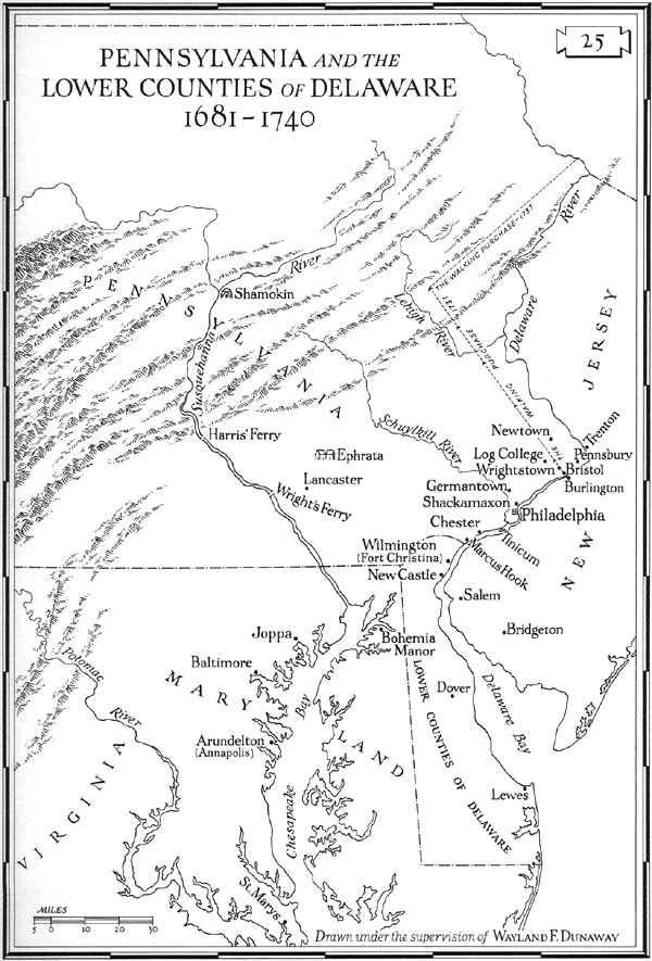
Pennsulvania from 1681 to 1720
- 1682 Mar 22nd Thomas and Robert Adams – Arrival in PA – Page 639 – PDF of the Book here. Robert 500 Acres and Thomas got 1,250 Acres.
- 1682 Dec 5th – Chester – Robert Adams – 200 Acres
- 1683 – Robert Adams 500 Acres
- 1686 Apr 8th – Bucks – Premi???sey Adams – 100 Acres
- 1701 Oct 31st – Chester – Benjamin Chambers – 200 Acres plus another 150 acres in a second listing.
- 1717-1718 – First wave of Scots Irish start in PA. The second wave had so well established the Scotch-Irish in the south eastern tier of counties in Pennsylvania that their influence even in political affairs in the Quaker commonwealth was becoming impressive.
- 1717 Oct 26th – ref to land acquired in 26 Feb 1681 – Richard Adams Upper Heyford, in Northampton Shire 500 acres of land. Lists John Adams as Heir and son. Authorizes and appoints Hugh Sharp, of the county of Burlington, in West Jersey to take up the Land – dated and signed.
Pennsylvania 1720
- 1722 Mar 1st – John Butcher desires the Grant of about 50-60 acres of land joyning on his tract where he dwells, the lands of Alexander Adams and Philip Bavele, near Drawers Creek, in Newcastle County.
- 1724 July 14th – Alexander Adams purchased Edward Smout’s 625 acres of land near Drawer’s Creek and other land Alexander purchased from Abraham Bickly – gives some to son-in-law Edward Gibbs.
- 1725-1729 – Second wave of Scots-Irish pours into Pennsylvania.
- 1725 – Richard Adams purchase is entered to be John Adams, his son, on Page 99 of Minute book but by will now produced Ricard gives to his other Son Nicholas Adams who in term gives it to his kinsman Richard Adams son of his brother John Adams. This group of Adams appear to have Intestate Records in Lancaster between 1729 and 1764. Nicolas dies in 1748 it looks like.
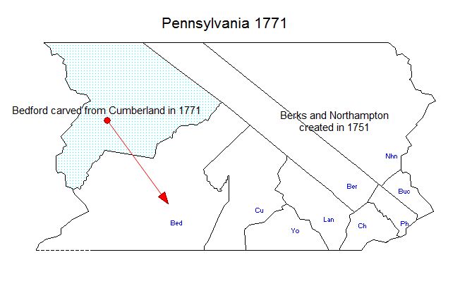
- 1729 – Lancaster County Created from Chester.

Pennsylvania 1730
- 1730 – Chambersburg – Formed According to Wikipedia??? – I think it was more like 1734/35 actually.
- 1733 Jan 16th – Lancaster – John William Adams – 200 Acres
- 1733 Jan 21st – Lancaster, Robeson Township on Pequea Creek – Thomas Lindsey – he appears to have been with John Long and James Lewis.
- 1734 Mar 28th – Lancaster, on Fishing Creek – Paxtang Township – Benjamin Chambers – Land Warrant – 200 acres. – more on — > Paxtang Township – The Old Paxton Church is the oldest Presbyterian Church still in use in PA. Congregation started in 1726. Might be a good place to look for Adams families.
- 1734 May 17th – Chester, Londonderry – Joseph Adams – Land Warrant – Almost 300 Acres
- 1734 June 11th – Lancaster – Joseph Culbertson – Land Warrant – 200 acres
- 1735 Oct 15th – Chester, Fallowfield – William Adams – Land Warrant – 280 Acres
- 1735 Jun 10th – Chester, Nottingham – William Cruther – land Warrant – 100 Acres
- 1737 Feb 15th – Lancaster, Paxtang – Robert, Benjamin and Robert Chambers – Land Warrant 700 Acres
- 1737 May 25th – Lancaster, New Londonderry – Martin Adams – Land Warrant – 200 Acres
- 1737 Jun 8th – Lancaster, Heidelberg Township – Frederick George Copp/Capp – Land Warrant – 215 Acres
- 1738 Sep 8th – Lancaster, On Susquehanna – George Adams – Land Warrant – 155 acres
- 1739 Dec 5th – Chester, Cain – John Culbertson – Land Warrant – 180.11 Acres
Pennsylvania 1740
- 1740-1701 – Third wave of Scots-Irish Migration. Famine struck Ireland in 1740 and was certainly the cause of the third large wave. An estimated 400,000 persons died in Ireland during 1740-41. This wave marked on America side, the first movement of Scotch-Irish in any numbers beyond the confines of Generous Pennsylvania to the southwest following the path through the Great Valley from Pennsylvania through Maryland, Virginia down toward North and South Carolina. (I believe this was the great Wagon Road).
- 1742 Mar 9th – Lancaster, Londonderry – James Caruthers – Land Warrant – 149 Acres
- 1743 Mar 31st – Lancaster, on Conococheague Creek – Robert Culbertson – 40 Acres
- 1743 Oct 12th – Lancaster, Cumru – John Adams – Land Warrant – 135 Acres
- 1743 Dec 9th – Chester, W. Cain – John Culbertson – Land Warrant – 200 Acres
- 1744 Feb 18th – Lancaster, Hopewell Township – Joseph Culbertson – 407 Acres
- 1744 – Greene (the city) – Joseph Culbertson – the oldest warrant found for Greene. Joseph Culbertson (1723-1794) and Alexander Culbertson (1714-1756) are brothers of Samuel Culbertson (1719-1789) the grandfather of Sisters Jane Culbertson (Family A364) and Nancy Agnes Culbertson (Family A265).
- 1744 – Mar 22nd – Lancaster, Tyrone Township at Conewago ws susq river – William Lindsay – 100 Acres
- 1745 Feb 6th – Lancaster, Cocalico Township – William Adams – Land Warrant – 93 Acres
- 1745 Oct 17th – Chester, Followfield – Joseph Adams – Land Warrant – 137 acres
- 1746 Jun 17th – Chester, Followfield – Joseph Adams – Land Warrant – 50 acres
- 1747 Jan 20th – Chester – Joseph Adams – Land Warrant – 25 acres
- 1748 May 23rd – Lancaster, Hopewell – Janet Culbertson – Land Warrant – 50 Acres
- 1749 Oct 12th – Antrim Township, Lancaster (then Cumberland County and finally Franklin County) – WIlliam Adams – 121 Acres. This is almost in Maryland.
- 1749 Jan 20th – Chester, Followfield – Joseph Adams – Land Warrant – 45 acres
- 1749 – Greene (The city) – Alexander Culbertson – Land Warrant
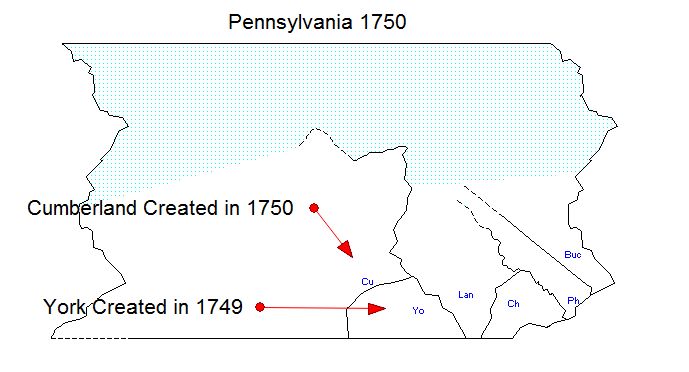
- 1749 – York County Created from Lancaster
- 1749 – Cumberland County created from Lancaster and non-county area.
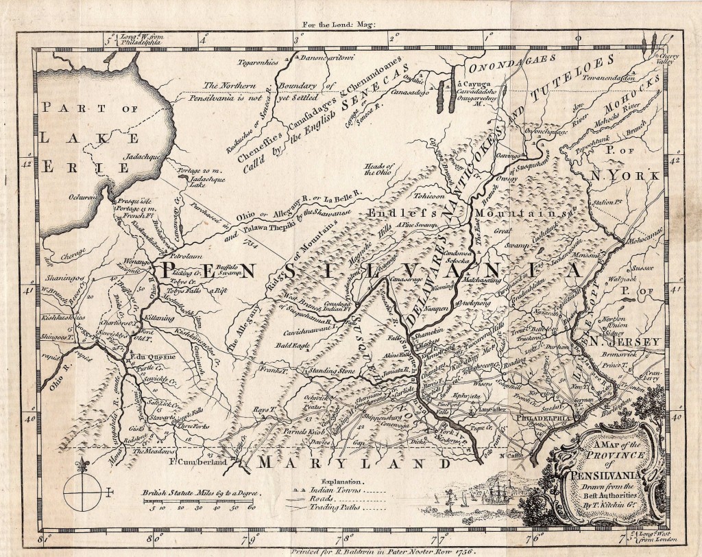
Pennsylvania 1750
- 1750 Aug 3rd – Cumberland, North side of Conodoguinal?? – Robert Caruthers – Land Warrant – 100 Acres
- 1750 Aug 3rd – Cumberland, Peensboro Township – William Culbertson – Land Warrant – 200 Acres
- 1750 Aug 14th – Cumberland, Lurgan – James Culbertson – Land warrant – 100 acres
- 1750 Aug 20th – Lancaster, Cumru – John Adams – Land Warrant – 54 acres
- 1750 Sep 10th – York, Manahan – Robert Adams – Land warrant – 100 acres
- 1750/1751 – Guilford – William Adams – Tax List – This is William Adams (1725 – 1792) from Family A364.
- 1751 Apr 22 – Lancaster – John Adams – 3 Land Warrants – around 440 acres
- 1751 – Guilford Township was formed. Guilford in 1751 would have covered Guilford (including the city of Chambersburgh) and Greene (the town) which was cut from Guilford Township in 1788.
- 1752 Jul 10th – Cumberland, Lurgan Township – Samuel Culbertson – Land Warrant – 50 acres
- 1752 Oct 13th – Lancaster, Hopewell Township – Alexander Culbertson – Land Warrant – 307 Acres – This is the father of Nancy Agnes Culbertson (Family A265) and Jane Culberstson (family A364)
- 1752 Nov 24th – Chester, Followfield – Patrick Adams – Land Warrant – 182 3/4 acres
- 1753 Oct 25th – Cumberland, Lurgan – Alexander Culbertson – Land Warrant – 50 acres
- 1753 Nov 20th – Cumberland, Peters – Robert Culbertson – Land Warrant – 50 acres
- 1753 Dec 12th – Chester, Coventry – William Adams – Land Warrant – 107.8 Acres
- 1755 – French and Indian War Begins – Seven Years War – Chambersburg was on the frontier during the French and Indian War. The area’s population dropped from about 3,000 in 1755 at the start of the war to about 300, with most settlers not returning until after 1764 when the peace treaty was signed
- 1755 Mar 22nd – Cumberland, On West Fork of Conococheagne beyond Kittatinny Hills – Alexander Culbertson – Land Grant – 100 Acres
- 1755 Aug 1st – Cumberland – Peters, Antrim and Path Valley near the Blue Mtns – Benjamin Chambers – Land Warrant – 200 acres each
- 1756 Feb 9th – York, Mount Pleasant – Thomas Adams – 50 acres – claimed by Joseph Adams for 118 acres in Feb 1787.
- 1756 Jul 14th – Cumberland, West Pennsboro – William Caruthers – Land Grant – 100 Acres
- 1757 Jul 14th – William Caruthers in 14th of July 1757 along with Benjamin Chambers
Pennsylvania 1760
People seem to really start pouring back in in 1765/66 based on the volume of land warrants I have seen in searching these files – there are a bunch of caruthers and culbertsons – so many I didn’t take time to list them below. Some Crockett too (note for ds)
- 1762 June 10th – Cumberland, West Pennsboro Township – James Caruthers – Land warrant – 50 acres
- 1762 July 29th – Toboyne, Cumberland – Thomas and William Adams – Land Warrant 200 acres each
- 1762 Nov 31st – Cumberland, North side of Kittatinny Hills – Samuel Culbertson – Land Warrant – 50 acres
- 1763 Feb 10th – Cumberland, Lurgan – Joseph Culbertson – Land Warrant 50 acres
- 1763 Apr 22nd – Cumberland, Lurgan – James Culbertson – LAnd Warrant 50 acres
- 1766 – Guilford, Cumberland – David Adams – Land – Neighbors John Vance, William Adams, John Lindsay and John Buck – This is David Adams (1720 – 1814) from Family A364.
Pennsylvania 1770
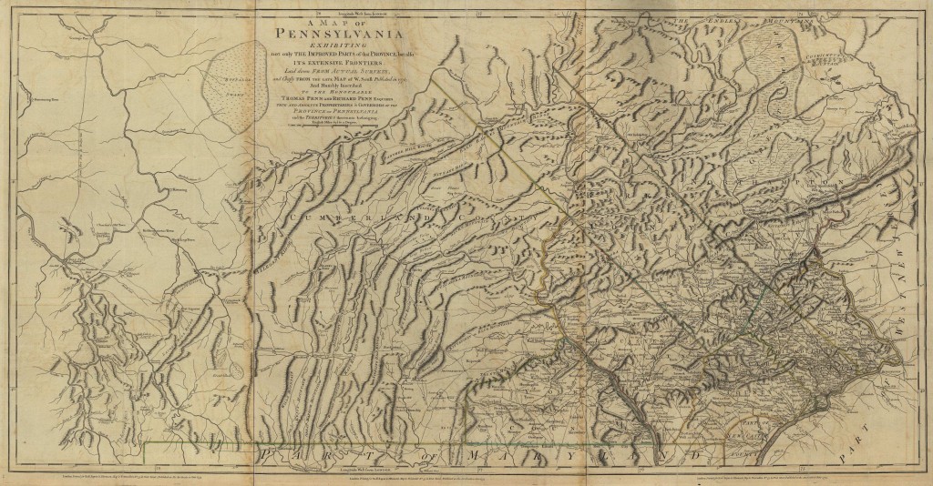
- 1773 – Westmoreland created from Bedford County and part of PA West Augusta District (WAD) Virginia
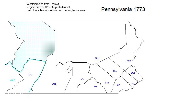
- 1773 Jul 23rd – Westmoreland, ???? – John Adams – Land Warrant – 300 Acres – Wow this is early in Westmoreland history. Could have been in Washington County
- 1773 Dec 1st – Cumberland, ???? – James Adams – Land Warrant 100 Acres
- 1774 June 18th – Cumberland, Toboyne – Robert Adams Jr. – Land Warrant – 50 acres
- 1775 March 2nd – Cumberland, Toboyne – Robert Adams – Land Warrant – 100 acres
- 1774 – Dunmore’s War Begins eventually culminating in the Battle of Point Pleasant on the Ohio near modern Point Pleasant, West Virginia on October 10th 1774
- 1775 – Chartiers – Martin Adams – Page 708 – History of Washington County Pennsylvania
Pennsylvania 1780
- 1781 – Washington County created from Westmoreland
- 1783 – Fayette County created from Westmoreland
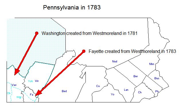
- 1783 Dec 26 – Cumberland, Guilford – William Adams – Land Warrant – xxx acres. This is the William Adams in family A364.
- 1784 – Franklin County created form CUmberland. Fayette gained from Westmoreland. Montgomery created from Philadelphia.
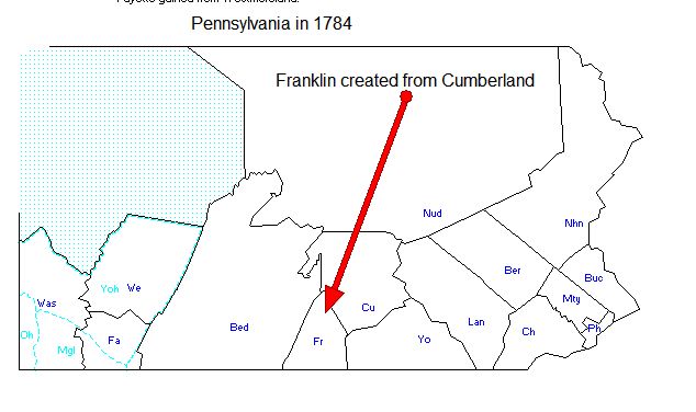
- 1784 Jul 1st – Bedford, Milford – Robert Culbertson – Land Warrant 150 Acres
- 1784 Aug 27 – Bedford, Tusseys Run – Richard Adams – Land Warrant – 164 acres
- 1784 Oct 13 – Washington, Wheeling – Levi Adams – Land Warrant – 318 Acres
- 1784 Nov 8th – Westmoreland, Ind co. – John Culbertson – Land Warrant – 300 Acres
- 1785 Feb 5th – Westmoreland, ???? – John Adams – Land Warrant – 300 Acres
- 1785 Feb 15 – Washington, Alleghaney County eventually – James Caurthers – 200 Acres – 200 Acres
- 1785 Jun 14th – Bedford, Bedford Township – Solomon Adams – Land Warrant – 50 acres
- 1785 Sep 10th – Bedford Quemajoning Township – Robert Adams Jr. – Land Warrant – 50 acres
- 1785 Dec 19th – Washington, Allegheny County – James Caurthers – Land Warrant – 150 Acres. This could potentially be the father of Jane Caurthers in Family A033.
- 1786 Mar 1st – Westmoreland, Ind Co. – Samuel Culbertson – Land Warrant – 300 Acres. This is an uncle to Jane Culbertson of A364 and Nancy Agnes Culbertson of A265.
- 1786 Mar 6th – Washington, Peters Creek at Lick RUn – George Adams – Land Warrant 250 Acres. This George may be the nephew of David and William adams in family A364.
- 1786 Mar 20th – Washington, ??? – John Adams – Land Warrant – 395 Acres
- 1786 Apr 5th – Washington, Chartiers – John Lindsay – Land Warrant – 100 Acres. This is the uncle of Jane Culbertson of Family A364 and Nancy Agnes Culbertson of A265. He signed David Adams (1792-1814) will of family A364 in Hopewell in 1814.
- 1786 Oct 5th – York, Chanceford – WIlliam Adams – Land Warrant – 270 Acres
- 1787 – Huntington County created from Bedford
- 1787 Jul 23rd – Bedford – Bedford Township – John Adams – Land Warrant – 125 Acres. This is a prime suspect to be the John Adams in Family A265.
- 1787 Nov 29th – Bedford – Bedford Township – Solomon Adams – Land Warrant – 200 Acres
- 1788 – Allegheny County created from Westmoreland, Washington and Northumberland
- 1789 Feb 24th – Lancaster – Isaac Adams – Land Warrant – 73 Acres
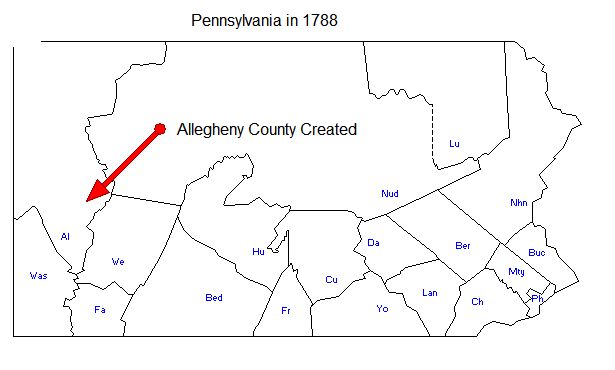
- 1788 Feb 26th – Westmoreland, NB Sewickhy?? – John Adams – Land Warrant – 120 Acres
- 1788 Mar 3rd – York, Fawn – William Adams – Land Warrant – 150 Acres
- 1788 Mar 16th – York Mt Pleasant – Joseph Lindsay – Land Warrant – 200 Acres
- 1788 Apr 8th – Washington, Buffalo – Robert Carothers – Land Warrant – 426 Acres. This one has a really good chance of being related to A033 as well given he lived in the same city as family A364.
- 1788 Sep 9th – York, Chanceford – Matthew Adams – Land Warrant – 50 acres
- 1789 – Mifflin created from Cumberland, Northerumberland. Allegheny gained from Washington
- 1789 Feb 26th – Washington, Chartiers – John Lindsay – 40 Acres. This is the uncle of Jane CUlbertson of Family A364 and Nancy Agnes Culbertson of A265. He signed David Adams (1792-1814) will of family A364 in Hopewell in 1814.
Pennsylvania 1790
(The land issued to Adams in Bedford from 1793-1795 is almost always 400 acres which makes me think this was for Military Service in the Revolutionary War. There are also a BUNCH of Capp people – makes me wonder if A033 isn’t related to the Capp instead of a Copp – they are in Cumberland and Lancaster too – a perfect migration path. There are also a ton of Capp in 1794 in Westmoreland)
- 1790 May 5th – Westmoreland, Huntgdn – James Carothers – Land Warrant – 300 Acres
- 1790 May 12th – Toboyne – James Adams – Land Warrant – xxx acres
- 1791 Jan 12th – York, Manahan – John Crothers – Land Warrant – 300 Acres. He gets 400 acres more in 1794.
- 1791 Sep 12 – Westmreland, Two Lick Creek – Garvin Adams – Land Warrant – 275 Acres
- 1792 – Somerset County Created from from Bedford
- 1792 Oct 19th – Bedford, on Dunning Creek – Joseph Adams – Land Warrant – 150 Acres
- 1793 Feb 21st – Bedford, Bedford Township – Elijah Adams – Land Warrant – 100 Acres
- 1793 Mar 26th – Bedford, ???? – Barbara Adams – Land Warrant – 400 Acres
- 1793 Mar 26th – Bedford, Quemahaning Township – William Adams – Land Warrant – 400 Acres
- 1793 May – Cumberland, Toboyne Township (listed as Toboin Township) – Robert Adams – 200 Acres Warrant
- 1793 Jul 19th – Bedford, Bedford Township – Alexander Adams – Land Warrant – 400 Acres
- 1793 Dec 3rd – Bedford, Bedford Township – Robert Adams Jr. – Land Warrant – 300 Acres
- 1794 Feb 10th – Bedford, Quemahoming – Elijah Adams – Land Warrant – 400 Acres
- 1794 Mar 4th – Toboyne – Robert Adams – Land Warrant – xxx acres
- 1794 Apr 25th – Bedford, Quemahoning Township – Robert Adams – 400 Acres
- 1794 Jul 18th – Bedford, Bedford Township – Samuel Adams – 400 Acres
- 1794 Jul 18th – Bedford, Bedford Township – John Adams – 200 Acres
- 1794 Jul 25th – Bedford, Bedford Township – Samuel Adams – 400 Acres
- 1794 Aug 13th – Bedford, Bedford Township – John Adams – 100 Acres
- 1794 Aug 13th – Bedford, Bedford Township – Solomon Adams , et al. – 250 Acres
- 1795 – Greene County created from Washington
- 1796 Jul 1st – Toboyne – Thomas Adams – Land Warrant – xxx acres
- 1797 Nov 13th – Washington (Armstrong Co) – Robert Adams – Land Warrant 275 Acres
Pennsylvania 1800
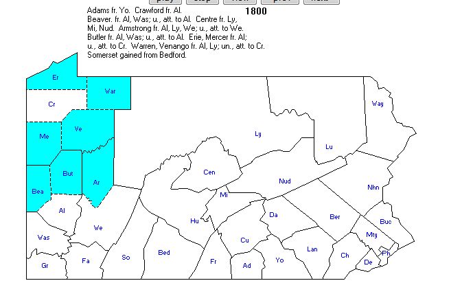
- 1800 – eight counties created from Allegheny
- 1827 Jan 2nd – Washington, Buffalo – Alexander Adams, John, et al. – Land Warrant – 252 Acres. This is definitely family A364.
- 1814 Jul 13th – Tyrone Township, Cumberland – David Adams, Sr. and Jospeph Neley – 150 Acres – adjoing land of James Diven, William Adams and others. Richard Adams witnesses that Neley lived on this land since 1792.
- 1818 Apr 28th – Toboyne Township, Cumberland – Halbert Adams in trust & ca, – 291 Acres – for application 1170 of William Adams Sept 9th 1766. William has died Intestate leaving Halbert Adams and Other Children to survive him.
