Parrish of Cumber in Londonderry Ireland
Background on Londonderry and Ulster
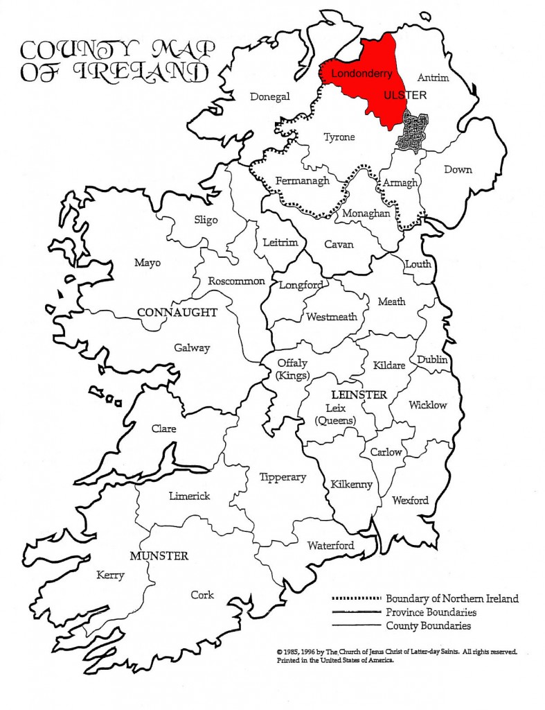
County Londonderry or County Derry (named after the city of Londonderry, also known as Derry) is one of the six counties of Northern Ireland and one of the nine counties of the Irish province of Ulster. Adjoined to the north-west shore of Lough Neagh, the county covers an area of 2,074 km², with a population of approximately 233,550.
County Londonderry was created by James I when he gave a charter to the Irish Society to undertake the new county’s plantation – the London prefix being added in reference to the London Livery Companies of the Irish Society. This charter is dated 29 March 1613,[27] and declared that the “City of Londonderry” and everything contained within:
| “ | shall be united, consolidated, and from hence-forth for ever be one entire County of itself, distinct and separate from all our Counties whatsoever within our Kingdom of Ireland-and from henceforth for ever be named, accounted and called, the County of Londonderry.[27] | ” |
This new county would comprise the then County Coleraine, which consisted of the baronies of Tirkeeran, Coleraine, and Keenaght; all but the south-west corner of the barony of Loughinsholin, which was then a part of County Tyrone; the North East Liberties of Coleraine, which was part of County Antrim; and the City of Londonderry and the Liberties, which were in County Donegal.[27][28] The Liberties of Coleraine and Londonderry were requested by the Irish society so that they could control both banks of the mouths of the River Foyle and the River Bann, and Loughinsholin to have access to sufficient wood for construction.[29]
As a result of the Local Government (Ireland) Act 1898, the city was detached from the county for administrative purposes, becoming a separate county borough from 1899. The county town of County Londonderry, and seat of the Londonderry County Council until its abolition in 1973, was therefore moved to the town of Coleraine.
From Harris‘s Hibernica, and also from Captain Pynnar’s Survey, Anno 1618:
| “ | The county of Coleraine,* otherwise called O’Cahan‘s country, is divided, as Tyrone, by ballyboes and doth contain, as appeareth by the survey, 547 ballyboes, or 34,187 acres, every ballyboe containing 60 acres or thereabouts. | ” |
English control of the territory remained nominal. Following the Flight of the Earls (1607) the Crown confiscated almost the entire county from its Irish aristocratic feudal owners. In 1609 the territory was given to the City of London Corporation and its livery companies, who received instructions to undertake its plantation.
The area for planting included:
- the entirety of County Coleraine
- the barony of Loughinsholin which comprised the then north of County Tyrone and the environs of Coleraine in County Antrim, together called O’Cahan‘s Country
- a small area of County Donegal around Lough Foyle
In 1613, this larger area became incorporated into the newly-founded County Londonderry, with its county town in the new walled city of Derry (also founded in 1613) on the west bank of the Foyle, opposite the destroyed town of Derry.
The county is often known in shorthand as Derry, despite there never have being a County Derry before the creation of County Londonderry. Prior to 1613 what became County Londonderry used to be parts of different counties: County Coleraine; the barony of Loughinsholin in County Tyrone; the North-East Liberties of Coleraine in County Antrim; and the North-West Liberties of Londonderry in County Donegal.
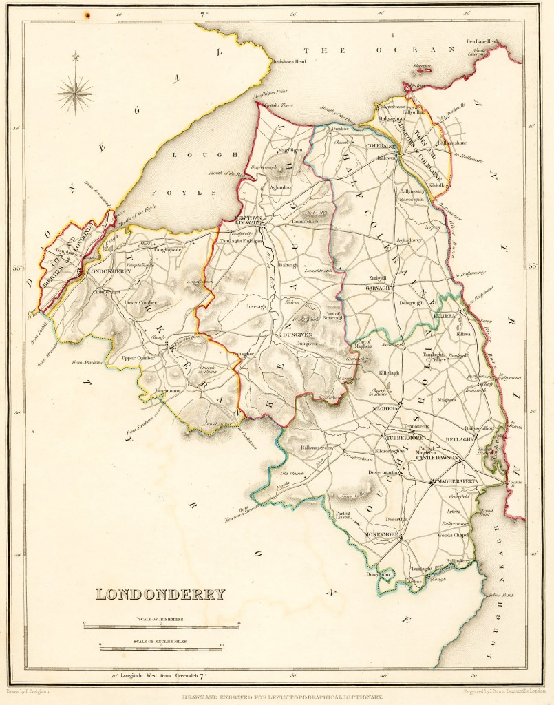
Below is the oldest map I could find easily of the Londonderry County area.
- 1622 Muster Rolls for the City & Liberties of Londonderry, Town & Liberties of Coleraine & Vintners’ Estate, Bellaghy
- 1630 Muster Rolls for Estates Londonderry County, Ulster Ireland
- 1630 Muster Rolls for the Baronies of Cary, Dunluce, Kilconway and Toome, Co. Antrim
- —> 1663 Hearth Money Rolls for Londonderry County Ulster Ireland
- —> 1669 Hearth Money Rolls for North and Mid Antrim
- THE INHABITANTS OF THE CITY OF DERRY / LONDONDERRY BEFORE THE SIEGE (c.1600-1688)
- —> 1740 Protestant Resident Returns for Londonderry County Ireland – Plenty of Adams, Little, McIntyre, Lindsay, McKee, Watt
- —> 1740 Protestant Householders’ Returns for the Baronies of Cary, Dunluce, Kilconway and Toome.
- 1766 Religious Census for the Parish of Ballymoney, Co. Antrim
- 1766 Religious Census for the Parish of Ballintoy, Co. Antrim
- 1766 Religious Census for some Parishes in Co. Londonderry
- Irish Immigrants to North American Prior to 1820
More on when the Ulster Plantation area and timing of colonization related to Scottish Presbyterians. So, more likely the Adams bunch moved to this area around 1690 form the border regions of Scotland. They certainly were not there before 1609 as it was nearly 100% Gaelic before that time.
Most of the Scottish planters came from southwest Scotland, but many also came from the unstable regions along the border with England. The plan was that moving Borderers (see Border Reivers) to Ireland (particularly to County Fermanagh)[citation needed] would both solve the Border problem and tie down Ulster. This was of particular concern to James VI of Scotland when he became King of England, since he knew Scottish instability could jeopardize his chances of ruling both kingdoms effectively.
Despite the fact that Scottish Presbyterians strongly supported the Williamites in the Williamite war in Ireland in the 1690s, they were excluded from power in the postwar settlement by the Anglican Protestant Ascendancy. During the 18th century, rising Scots resentment over religious, political and economic issues fueled their emigration to the American colonies, beginning in 1717 and continuing up to the 1770s. Scots-Irish from Ulster and Scotland, and British from the borders region comprised the most numerous group of immigrants from the British Isles to the colonies in the years before the American Revolution. An estimated 150,000 left northern Ireland. They settled first mostly in Pennsylvania and Virginia, from where they moved southwest into the backcountry of upland territories and the Appalachian Mountains.[53]
Parrish of Cumber
CUMBER, UPPER, a parish, partly in the barony of STRABANE, county of TYRONE, but chiefly in that of TIRKEERAN, county of DERRY, and province of ULSTER, 7 1/2 miles (N. E.) from Londonderry; containing, with Claudy (which has a daily penny post), 5430 inhabitants.
The early history of this parish cannot be satisfactorily traced, further than that St. Patrick, having crossed the Foyle, founded several churches in this district, one of which occupied the site of the present church of Cumber.
The original name is variously written by early historians; the present is modern, and acquired since the taxation of Pope Nicholas in 1291. At the Reformation the rectory belonged to the abbey of Derry, and was given by Jas. I. to the bishop, as part of the abbey lands.
In 1622, it appears, by the Ulster Visitation book, to have been held with Banagher. The ancient parish of Cumber was the most extensive in the diocese, until 1794, when it was divided into Upper and Lower Cumber, by order in council: the parish of Upper Cumber, according to the Ordnance survey, comprising 26,202 1/4 statute acres, of which 23,072 3/4 are in Derry, and 3129 1/2 in Tyrone; the latter form a hilly district amid the Mounterloney mountains. In some parts, particularly on the Walworth estate, and on that of Learmont, the land, though hilly, is well cultivated; the extensive bogs are being worked out, and brought into cultivation.
The inhabitants combine the weaving of linen cloth, with agricultural pursuits; there are several commodious and excellent bleach-greens on the Faughan water, none of which, however, are now at work. The southern parts of the parish consist chiefly of mountains, the principal of which is Sawel, the highest in the county, being 2236 feet above the level of the sea; its summit is on the boundary between two counties.
These mountains afford excellent pasturage on every side; and the rivers Faughan, Glenrandle, and Dungorthin have their sources in them. There are large woods and much valuable timber in the demesne of Park-Learmont; and the plantations of Cumber, Alla, and Kilcatton greatly embellish the surrounding scenery. There are several large and elegant houses, of which the principal are Learmont, the seat of Barre Beresford, Esq.; Cumber House, of John H. Browne, Esq.; Kilcatton Hall, of Alexander Ogilby, Esq.; and Alla, of the Rev. Francis Brownlow.
The living is a rectory, in the diocese of Derry, and forms the corps of a prebend in the cathedral of Derry, in the patronage of the Bishop: the tithes amount to £740. The glebe, situated in Glenrandle, half a mile from the church, consists of the townlands of Alla, Gilky Hill, and Tullentraim, containing 1508 statute acres.
The church is a large modern edifice, with a small bell turret on the western gable, erected in 1757, on the site of an ancient building. In 1831, eight townlands were separated from the parish, to form part of the new district or parish of Learmont, and the rector of Upper Cumber has the alternate presentation to that perpetual cure. In the R. C. divisions the parish is partly included in the union or district of Banagher, and partly forms the head of a district, comprising also a part of that of Lower Cumber; there are chapels at Claudy and Gortscreagan.
The Presbyterians have a meeting-house at Claudy, in connection with the Synod of Ulster. The parochial school, situated on the glebe lands of Alla, is well built and convenient; it is supported by the trustees of Erasmus Smith’s charity, and is under the management of the rector, who has endowed it with two acres of land. Male and female schools were built and are supported by the Fishmongers’ Company; and they have also excellent male and female schools at Gortilea and Killycor.
There are also schools at Ballyarton, Craig, Kilcatton, and Claudy. A female school at Claudy is principally supported by Lady Catherine Brownlow, who likewise contributes to some others. A female work school at Cumber was built and is supported by Mrs. Browne and other ladies of the parish. A male and female school at Learmont is principally supported by the Beresford family. There are also Sunday schools and a private day school.
At Mulderg is a large dispensary, built and supported by the Fishmongers’ Company. There are the remains of a druidical altar at Baltibrecan; and at Altaghoney were discovered, in the summer of 1835, three stone coffins, each covered with three flag stones, and in each an urn containing ashes, calcined bones, &c. The graves were two feet deep in the gravel, where 8 feet of bog had been cut off the surface; and near the coffins were two idols, carved out of solid oak, which, with the urns, are now in good preservation, in the museum of Alex. Ogilby, Esq., of Kilcatton, who has also a good collection of landscapes, groups, &c, more than 200 of which are from his own pencil.

